The last two years I have made it my goal to hike every trail in the Chuckanuts – everything from the most popular trails, such as Oyster Dome, Pine/Cedar Lakes, and Fragrance Lake, to some obscure trails that I just stumbled upon using the Gaia app, such as the Secret Trail or the Fiona Ridge Trail.
As I have hiked through the Chuckanuts, and joined several work parties, the thought grew that perhaps there was a way to hike the whole area, north to south (or vice versa). There are several great east/west trails, and lots of trail through the Chuckanuts, as well as Blanchard Mountain, but nothing really in between in the Oyster Creek area.
There are some older maps showing a “Lost Lizard Trail”, which would connect the Lost Lake area in the Chuckanuts to Lizard Lake on Blanchard Mountain, making a north-south trail hike possible. However, I haven’t been able to find it, and through online research it seems like no one else has either. Best I can guess, it was a proposed route at some point that was never completed (non-existent “Lost Lizard Trail” below):
So i discovered with the Gaia app/website you could easily create a route using existing trails, roads, and even mountain biking and motorcycle trails. It took some work, but I was finally able to come up with a route that started in the Fairhaven district of Bellingham, and allowed you to hike about 14 miles in a southerly direction through the Chuckanuts, connect with Blanchard Mountain, and then finish on Chuckanut Drive at the base of the Oyster Dome trail.
I proposed this route to a few friends who seemed into doing it – 14 miles is a great day hike, but between work and family commitments, conflicting schedules, etc, it hasn’t worked out for all of us to get together to do it. So having a free day, dry, and temps in the low 60’s I decided to just go for it. I decided to drive to the Alaska Ferry Terminal in Fairhaven, starting at sea level, and working my way south from there.
The trail starts out pretty mellow, following Padden Creek initially as you make your way past the Fairhaven Historic District on the way to Fairhaven Park. You have to leave the trail for a few hundred yards, walking past the tennis courts, restroom and parking lot before getting back on trail at the Chuckanut Community Forest (or as locals refer to it, the Hundred Acre Woods). There are quite a few options for ways to get through this section, but with a goal of connecting with the Interurban Trail, I decided to take the Main Vain and Swamp Trails.
The Interurban Trail then connects with Arroyo Park and the Lost Lake Trail – in working on this thru trail, I had to decide between using the lower Lost Lake Trail, or the higher, rougher Ridge Trail. Since this was my first time, and not knowing what the middle section of the trail was going to be like, I decided to go with the easier Lost Lake Trail. In doing it this way, it isn’t a ridge hike, but it is a great north-south route.
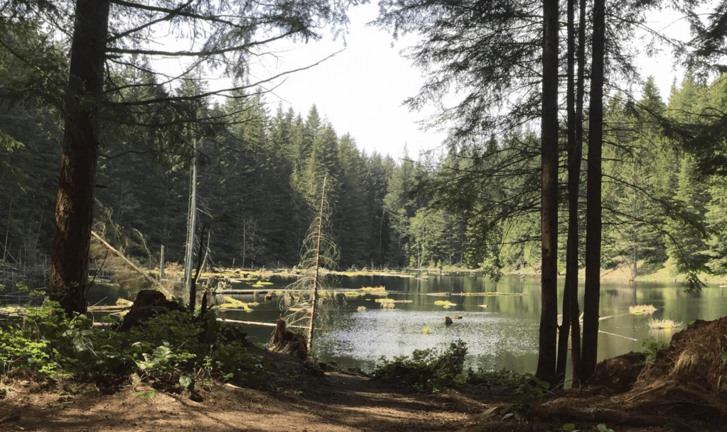
One of the things I liked about this route was that it followed the east side of Lost Lake, which is one of the better sections of trail in the Chuckanuts, but for some reason they don’t show it on the trail maps. There must have been a decision at some point to de-emphasize that trail, and it seems to have happened at the same time they stopped permitting camping at Lost Lake. In any case, there is a large rock in the mid-section of the lake that made for a great lunch spot (enjoyed a can of Bitburger there as well).
I was excited for the next section – it was the middle connecting the Chuckanuts with Blanchard Mountain – no man’s land! After reaching the south end of Lost Lake, you hit a Y in the trail – going to the right takes you back towards multiple trails in the Chuckanuts, but going left takes you out of the area and into what I thought would be primarily logging roads. It wasn’t a great start, as the trail was quite overgrown – I had to use my trekking poles to push my way through. However, for trails that supposedly aren’t used that often, it wasn’t quite as bad as I expected.
Eventually the trail did merge with logging roads, crossing the upper section of Oyster Creek, past a pond called Easy Reach Pond (where you can’t really see any water – it seems to just be an overgrown swamp), and into a network of motorcycle / mountain biking trails. There was only one clear cut section, and it was rather small – for some reason I expected more clear cuts in this area.
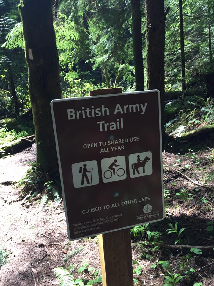
This section was all pretty mellow – not too much in the way of hills, just easy hiking. However, that changes as you approach the base of Blanchard Mountain. I knew there would be some uphill hiking involved – after all I was at about 800 feet and I knew Lizard Lake is at about 2000 feet. The last section of logging road was a pretty gentle uphill, but then it met up with the British Army Trail – a trail that I’ve been looking forward to checking out. I’m not sure how it got the name, but it didn’t take long for me to decide it was because of how steep the trail was – it would be good training for any army! It’s a great trail though – it doesn’t get as much attention as it deserves, but it’s likely because there really isn’t a proper trailhead at either end of the trail.
Eventually you get to the shores of Lizard Lake, probably my favorite lake in the Chuckanut/Blanchard area – it’s not the largest lake, but it is really nice and has probably the best campsite in the area. I haven’t reached the lake from this direction before, but I liked how it came close to the shoreline.
At this point I had reached the base of the Lily-Lizard Connector Trail, the last uphill of the route, so I took a breather and drank half a liter of water and refueled with a Snickers. However, I don’t think I was dreading this uphill as much as the final downhill section – 2000 feet of descent on the Oyster Dome Trail….
Well, this final section took much longer than I had hoped – distance-wise it was only a few miles, so it should have only taken an hour. However, after the previous 13 miles, my pace slowed down quite a bit as I descended. However, it was awesome to finally reach Chuckanut Drive, just shy of 9 hours after I started (this time included a 30 minute lunch break, and a couple of other 15 minute stops along the way).
Oh, if you are paying close attention you may have noticed that the Gaia GPS app said this would be a 14 mile through hike – in the end, it somehow ended up being 18! There was the extra bit at the beginning, from the Alaska Ferry Terminal to Fairhaven Park, but that likely is just shy of a mile. So somehow the actual hike was about 3 miles longer than I expected. It was fine, but I’m still not sure how or why the app was so off.
I am happy to have finally completed this route, and as sore as I am a couple of days later, I’m already planning to do it again, possibly this coming week. I am going to go in the opposite direction, starting with the steep uphill Oyster Dome climb, but I may veer off and take the Pacific Northwest Trail up to Lily Lake instead. Knowing my knees, I’m thinking it may be better to do it as an uphill climb and get it out of the way first, and then have the gradual downhill from the Lost Lake area to Fairhaven to look forward to. I am also thinking of doing the Ridge Trail from Lost Lake to Arroyo. These changes add a few miles, but I think after doing it I’ll be able to combine the two to come up with the definitive Chuckanut/Blanchard thru hike route.
I really can’t recommend this route enough – you really get to take in everything the area has to offer – great views, lakes, moderate uphills and downhills, and it also works year round (other than occasional winter snows). I’m not 100% sure how access works in the middle section, as parts of it are not DNR or state park land (maps just say it’s “Private Land”), but I didn’t see any signs saying you couldn’t hike through, and didn’t see any logging trucks or equipment. In fact, I didn’t see a single person from Arroyo Park until Oyster Dome Trail – probably because it was a Thursday, but I was surprised not to see anyone in the Lost Lake or Lily/Lizard Lake sections.
If you have any questions about this hike, you can send me an email at records@dblcrown.com. I would be more than happy to send GPX / KML file of the route to you as well.
